While looking at an old map of Constantinople, Istanbul today, I felt lost even if I knew my way around. Some buildings were there, while others not yet. Old maps can be unsettling, but ancient maps of cities you just visited even more so.
When I look at an old map, I first search for great cities with familiar names, then look for landmarks that might have survived the centuries: a church, a fortress, a forest, a river, or at least a mountain range that will definitely still hold its place.
Next, I turn to the edges of the map. Here hide the more intriguing details: a little road disappearing into a forest, a village marked then, where none will stand today, a river that has since changed its course, or a name that survived on the map – but nowhere else. Sometimes there are even blank spaces marking lands where the cartographer knew something lay, but could not quite say what…
Then there are the things that seem almost wrong today.
A coastline bends where it should not. A mountain appears twice. A road crosses a river where no bridge could possibly have stood. A city is drawn large enough to matter, yet today only a field or a handful of stones remains. Sometimes a place appears on one map and vanishes from the next, leaving behind only the faintest trace that anyone once believed it existed.
That is what I love about old maps: they show us where people once lived. They also show us what people thought was there – what they had heard about but never seen; what they hoped to find and what they feared. And, perhaps most revealing of all, what had disappeared.
An old map is therefore more than geography. It is a record of uncertainty, history drawn rather than written. Like a historical fiction book.
The streets, walls, towers, harbours and names are only the beginning. Behind every line is a decision: someone chose what to draw, what to name, what to enlarge, what to leave blank and what to omit entirely. Sometimes the smallest mark on the page—the road that no longer exists, the misspelled name, the fortress reduced to a tiny square—can tell us more about the world that made the map than the grandest city printed across it.
Often, when I write historical fiction, I need a map before I need a sentence.
I use old maps in my upcoming novel, Beneath the Snow, because my characters cannot even look up a road on it. They must know the landscape as people of their time knew it: by walls, rivers, gates, roads, landmarks and – mostly – by memory and word of mouth.
” ‘It is strange,’ said the young one, German by tongue. ‘The road cartographies of Antiquity, the elusive Peutinger Map, were once many. Now? Perished for want of scribes. What remains? Nothing of roads, save the memory of itineraries muttered by mouths. Only portolani endure, the sea-charts. But step upon land and you’ll seek charts in vain.’”
(Beneath the Snow by Patricia Furstenberg)
So when I found this old map of Constantinople, I found myself asking a different question than what did this city look like?
I asked: What did the mapmaker want his reader to see?
Constantinople, Istanbul—and a city between worlds
Between the 13th and the 18th centuries, southeastern Europe lay between three powerful empires competing over domination: the Ottoman, Habsburg and Venetian.
Although their borders were almost constantly places of war, southeastern Europe was also a place of trade, travel, diplomacy, languages and ideas. Constantinople, Vienna, and Venice were great centres within networks that stretched across the Balkans, the Adriatic, the eastern Mediterranean and far beyond.
Constantinople, especially, had undergone one of the greatest transformations in its long history especially after Mehmed the Conqueror’s conquest of 1453, after which the city’s population grew dramatically. By the sixteenth century it had become a vast imperial capital filled with new mosques, marketplaces, fountains, palaces and other foundations of Ottoman power.
Yet the older, byzantine city did not simply disappear. The name Constantinople (Konstantiniyye in its Arabic, official adaptation) continued to evoke Byzantium and the Christian empire that had preceded the Ottomans. At the same time the phrase “eis tēn polin“ a Medieval Greek expression that translates to “into the city“ was already preferred by he Greek population (Eastern Orthodox Christians). This vernacular expression gradually became Istanpolin on the lips of the neighboring Turkish speakers.
We can see how Istanbul and Constantinople already coexisted in the minds of those who mentioned this city. A city can change rulers without losing its ghosts.
A city seen through European eyes
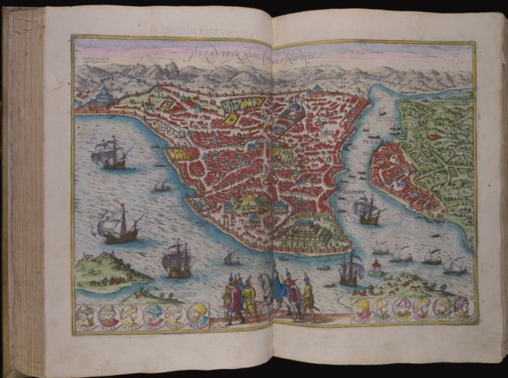
One of the maps that catches my attention is Georg Braun’s depiction of Constantinople in Civitates Orbis Terrarum, the first printed atlas dedicated to maps.
NOTE 🙂 on Braun’s map of Constantinople the Golden Horn appears positioned toward the lower-right side of the image because of the vantage point and artistic perspective chosen by the cartographers. See below:

Its title, Byzantium, now Constantinopolis, already tells us something important: the map describes a city in the present, but it is also reminding its European audience of the city’s past.
Constantinople was never simply a distant imperial capital. It was a destination, a marketplace, a source of news, power and fear—and a place toward which roads, rivers and ambitions converged.
If we look closely we see that the city is more than streets and buildings. The map draws attention to imperial mosques, churches and the places where European merchants established themselves. It is therefore a map, but also an argument: it tells the viewer this is Constantinople now, but remember what stood here before. This is a city where several histories meet.
We also see the walls surrounding the city and, in the foreground, the sultan is shown riding a horse, surrounded by his entourage and infantry armed with bows and arrows. Also, past sultans are portrayed in the medallions under the map.
And that is one of the reasons I find historical maps so valuable when writing fiction. A modern map tells me where a place is, but an old map can tell me what mattered there.

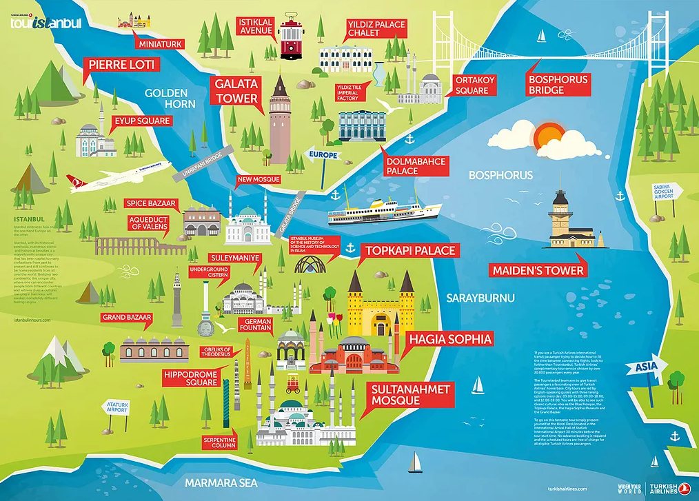
You can see how on Braun’s map left) the Golden Horn channel reaches way below, south of Topkapi Palace (the one with many terraces), while S Sophia (Hagia Sophia) in blue is moved to the left. The Sultanahmet Mosque was not yet built.
Pera is also in a different place, to the right, where Asia would be. This is a visual clue that Pera, a fortified Genoese merchant colony with its own separate administrative identity, the primary quarter for foreign diplomats and European merchants, was perceived as being apart.
There are many other maps in Georg Braun and Frans Hogenberg’s atlas 🙂
Three capitals, three visions
Constantinople was not alone in being transformed by imperial ambition. Vienna was becoming the great Habsburg centre, while Venice maintained its extraordinary position as a commercial and diplomatic bridge between the Mediterranean and the lands beyond it.
The maps of these cities reveal very different ideas of power.
Braun’s Vienna emphasizes churches and massive fortifications. The city appears as a true bastion against an ever-constant Ottoman threat. It was the dream of many Ottoman sultans to expand the borders of the Sublime State to the prize that Ottoman ambition called the Beç Kızıl Elması, the Red Apple of Vienna.
Sultan Mehmed the Conqueror led his troops as far as Belgrade, in 1456 (John Hunyadi successfully defended the fortress only to die three weeks later of the plague). It was his great-grandson, Sultan Suleiman the Magnificent, who besieged Vienna in 1529 but failed to capture it. Ottomans tried one more time in 1683 led by Grand Vizier Kara Mustafa Pasha (under Sultan Mehmed IV who remained in Edirne) but Polish King Jan III Sobieski broke the siege. Vienna stood.
Ironically, although after the fall of Constantinople, on May 29 1453, Sultan Mehmed the Conqueror rode his horse to the doors of the Great Church (Hagia Sophia, Holy Wisdom) before converting it to a mosque (the first call to prayer was recited on June 1), two hundred years later, after the 1683 defeat of the Ottoman army in Vienna, a large number of Ottoman cannons and weapons were used to cast a massive bronze bell, the Pummerin bell, which was hung in St. Stephens Cathedral in Vienna (it last tolled on Easter 1937).
Venice is also different. Braun’s map reveals a dense urban world of canals, landmarks, merchants and communities, including Jewish residents (#144 on the map) and traders from different parts of Europe and the Ottoman world.
Perhaps that is why old maps are so useful to a historical novelist. They do not merely show us geography. They reveal priorities:
What did the mapmaker think was important enough to draw?
What was given a name?
What was enlarged?
What disappeared into the margins?
Who was expected to read the map—and what did its maker want that reader to believe?
Maps were made for people who moved
The more I explore these old maps, the more I realise that they belong to a world in motion: ships crossed the Mediterranean. Merchants travelled between ports. Mostly diplomats and merchants crossed borders. Soldiers marched along roads and rivers. Travellers followed the Danube from Vienna towards Budapest and Belgrade and eventually towards the Black Sea and Constantinople.
Roads could connect places belonging to rival powers. Fortifications mattered, but so did the routes between them. Therefore, the boundaries between empires could be fiercely contested, yet people crossed them constantly. The map of a borderland could never be entirely still.
And behind all that movement was another form of crossing: language. German, Turkish, Greek, Italian, Albanian, Armenian, Latin and other languages were part of everyday communication across these imperial borderlands. The map on the page might divide territories but the people living there were often far less easily divided.
What an old map cannot tell us
This is where the modern photograph becomes interesting.
I recently stood in Constantinople—Istanbul and photographed the same area shown on Braun’s 1575 map.
I stood at the tip of the peninsula from Brown’s map, left of the ship with sails. I stood at the foot of the Galata Bridge, watching over Europe on the left and Asia on the right:

The contrast is almost disorienting.
The mapmaker had his paper. I had my camera.
He had towers and walls, ships and landmarks. I had roads filled with traffic, signs and people carrying phones.
Yet the ground beneath was the same. It is the magic of historical places. The centuries may have altered almost everything the eye can see, but the earth remembers. Sometimes an old map makes that continuity visible.
The map inside the novel
This is also why maps appear in Beneath the Snow. My characters inhabit a world in which geography can mean survival. Land maps were only just beginning to be made widely available.
A road was not only a line connecting two places. A mountain pass offered protection—or danger. A river could be a boundary, a route or an escape. A city wall meant safety until the wrong person opened its gate.
When I write about the fifteenth-century world of Transylvania and its connections with the wider Ottoman and European realms, I want to know what my characters would have known.
Which routes would have been familiar? Which places would have existed only as names known by merchants or messengers and which were widely known to travellers?
Old maps remind us that, once, people did not experience their world as a collection of historical facts. They lived in it but they also feared it. They traded across it. They fell in love across its borders. They carried letters, books, medicines, rumours and secrets from one place to another during lengths of time hard to imagine today.
When I place my photograph beside the old map, I am struck by what has changed and by what has not. But for a moment, the two images speak to each other. One says: this is the city as we understood it then. The other says: this is the place where I stood now.
Between them lies centuries of history. And, sometimes, that is enough to open a door. You only have to step through.
Fascinating info on maps. I admire the research you do, Patricia.
Not all as reliable as one would imagine 🙂 Thank you, Darlene.
Interesting post about ancient maps. I’ve always been fascinated by maps and globes. You make some excellent points about we need to interpret ancient maps.
Thank you so much, Janet. I’ve always felt that old maps are more than just geographical records; they hold little glimpses of how people saw and understood their world. The real joy lies in looking beyond the lines and names to discover the stories they might tell. I’m delighted you enjoyed the post!
Cities and maps certainly evolve with time. With the centuries come big changes. It was interesting to read about the changes in Constantinople, Venice and Vienna. Another thing that has change is people’s attitudes and the signs on buildings. That may not show up on maps. However, I have an old friend who grew up in Dallas where I live now and he was pointing to buildings I drive by every day telling me, on this building there used to be a sign that said “this and that” and it was very shocking racist stuff I cannot write here. Times change.
You make such an interesting point, Thomas. Cities change not only in their streets and buildings, but also in the attitudes and values reflected in everyday life. Those old signs your friend remembers are a reminder that history lives in people’s memories as much as it does in maps and monuments. Thank you for sharing this thoughtful perspective.
It’s a fascinating subject on so many levels, Patricia. Where a place has changed greatly an old map can be a valuable resource. The Great Fire of London in 1666 caused an entirely new city to be built in the aftermath, so it’s a historical necessity that we have maps of the place as it was before. Paris too, before the wide boulevards put in by Haussmann, has maps of how it was originally – so useful when reading Balzac’s ‘Pere Goriot’, or Hugo’s ‘The Hunchback of Notre Dame’ to get a feel of the city. At a personal level I too have walked the streets of Islington in London remembering that my father once walked there. The house where he was born has gone, the area redeveloped and a car park now occupying the site; but maps of the area as it used to be helped me locate the address which he left. Maps; such wonderful things, and invaluable when researching for your own historical novels. Many thanks for an engrossing and fascinating post.
Laura, I found the part about your father especially moving. How wonderful that old maps helped you trace his footsteps, even though the house where his story began is gone. There is such a special feeling standing where someone you love once stood, knowing the place has changed but the connection remains. I feel the same. Thank you for sharing this with me. ❤️
Wow, these ancient maps are fascinating Patricia. All your intense research is so evident in your books.
Aren’t they, Debby? 🙂 I think so too. I enjoyed learning about them and finding a way to include then in my books. So, thank You So Much xoxo 🙂
I love old maps and have a copy of an old one for the area I live in now. The Bishop’s Palace here is now a ruin, but you can still see evidence of the lavish lifestyle these wealthy people enjoyed and the small settlement that helped to support it. Fascinating information, Patricia. Your research is impressive.
So happy you visited Trish. Saday, villagers all over the world worked hard to sustain other’s lavish lifestyle.
It is amazing at what rate a place can change, if it does. And sad to see so much of an exciting and meaningful past erased. At least maps can still tell a tale. 🙂