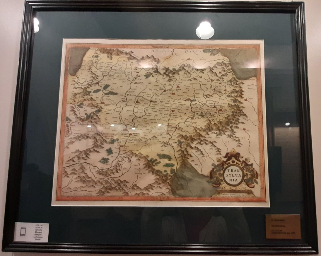
Stories at Bucharest’s Map Museum unfold through three remarkable early maps: Lorenz Fries’ 1525 map of Transylvania, his 1541 map of Dacia, and Gerardus Mercator’s 1595 map of Transylvania, each offering a glimpse into how cartographers of the past imagined and recorded these historic lands.
You can imagine how excited I was to study them 🙂
But what does an old map tell us?
At first glance, it might seem to be nothing more than lines, rivers, mountains and names. But as soon as we look closer, a map becomes something else as well: a record of how people understood their world.
This is one of the reasons I found the National Museum of Maps and Old Books in Bucharest so fascinating.
As a traveller and historical fiction writer, I enjoy having a map to guide me and, honestly, even save me. Growing up in Romania I loved drawing maps. So visiting the National Museum of Maps and Old Books in my beloved Bucharest and being surrounded by more than 1,000 historical and artistic examples felt rather like stepping into a childhood dream.
The museum’s collection contains maps dating as far back as 1525, along with cartography books, maps of continents and oceans, maps decorated with sea monsters, and treasures from places as distant as Japan.
Most of the collection has been donated, and the museum is considered the fourth-largest map museum in the world by number of exhibits.
Yet it is not an enormous institution. Its relatively small size is part of its charm, especially because space restrictions mean that many exhibits cannot remain permanently on display. A return visit can therefore reveal something entirely new.
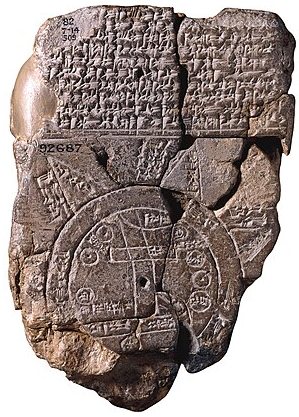
What is the oldest known map, ever?
How Were Maps Created?
Maps may appear commonplace to us today, but creating one was a meticulous art involving craftsmanship, patience and dedication. It was not simply a matter of drawing a landscape.
An artist would begin by etching intricate details into a gravure plaque: mountains, rivers, symbols, words and other features. Each element had to be created as a mirror image of the final design.
Once the etching was complete, ink was poured into the grooves of the engraving.
A damp sheet of paper, made from cloth, was carefully placed on top. Unlike modern cellulose paper, this material was produced in paper mills from rags and fibres. It was remarkably durable and resistant to the effects of time and sunlight.
Under the press, the paper absorbed the ink, transferring the engraved details onto its surface. And finally, the map was done.
When I think about that process, I am struck by how much human labour is hidden inside something we now unfold without a second thought.
The 1525 Map by Lorenz Fries where Transylvania has an unusual placement-and why!
One of my favourite discoveries at the Map Museum was Lorenz Fries’ 1525 map, which provides an intriguing glimpse into historical geography.
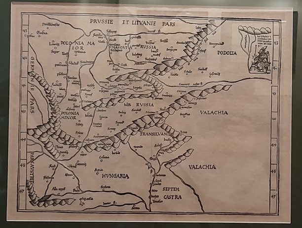
This remarkable map, one of the oldest surviving examples of the Renaissance period, depicts a geographical area that now includes parts of Romania, Lithuania, Hungary and Poland.
What surprised me most was its unusual orientation. Unlike modern maps, Fries’ map lacks the familiar cardinal directions. Instead, it combines northern and eastern perspectives in a way that can seem confusing to us today but was entirely intentional at the time.
In fact, the word orientation derives from the Latin oriens, meaning east. During the medieval period, many European maps placed east at the top, reflecting the direction’s spiritual significance and Jerusalem’s importance in the Christian worldview. On such maps, west lay at the bottom, north to the left, and south to the right.
Why is Wallachia marked twice, and why does it appear above Transylvania?
This explains something else that might otherwise seem a cartographer’s mistake: why is Wallachia marked twice, and why does it appear above Transylvania? The answer lies partly in orientation, but also in the geographical knowledge of the time. For centuries, European mapmakers sometimes confused the regions of Wallachia and Moldavia, even labelling them with variations of “Wallachia, which some call Moldavia” and “Moldavia, which some call Wallachia.”
Uncharted territories, meanwhile, were sometimes left blank or marked with the ominous phrase Hic sunt leones — “Here be lions” — a warning that the lands beyond were unknown or unexplored.
Suddenly, the map becomes much more than geography. It becomes a window into a medieval worldview, revealing not only how people understood the lands around them, but also the limits of their knowledge and the assumptions through which they interpreted the world.
Standing in front of Fries’ map, I couldn’t help but be impressed by how seemingly simple decisions — which direction should face upwards, what to call a neighbouring region, or where to leave the parchment empty — reveal so much about the beliefs, uncertainties and geographical understanding of the people who created it.
The map was included in the edition of Ptolemy’s works published by C. Trechsela.
Transylvania on an Old Map from 1595 by Gerardus Mercator
As a Romanian-born writer, I naturally found this detailed maps of Transylvania particularly fascinating.
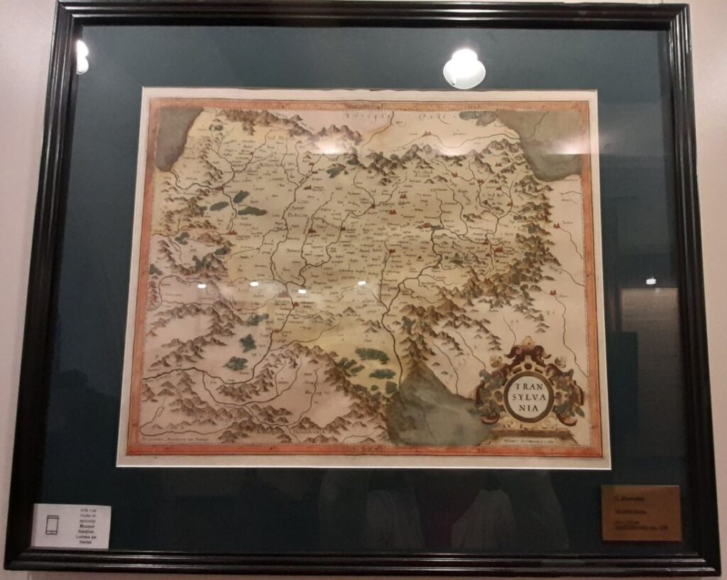
This sixteenth-century map by Gerardus Mercator is hand-coloured in red, yellow, green and brown watercolours. Its representation of the terrain is more artistic than scientific, while settlements are marked according to their perceived importance, some with small red dots.
What caught my attention was the way the province is divided into historical regions, though no boundaries separate them: Wurtzland, the Land of Bârsa (the Burzenland around Brașov); Altlandt, the Old Land; Weinland, the Wine Land; and Nosnerland, the Bistrița region. The map also marks the mountain passes through the Carpathians towards neighbouring lands, as well as the upper courses of the Mureș and Olt rivers.
In the lower-right corner, the title sits within an ornamental cartouche decorated with curling scrollwork and plant and floral motifs. Beneath it, the map’s scale is engraved with the inscription Miliaria Germanica com:. This is an abbreviation of the Latin Miliaria Germanica communia meaning “common German miles,” identifying the unit of measurement used in the map’s scale
Looking at Transylvania through the eyes of a sixteenth-century cartographer is a reminder that the landscape we know today has been continually renamed, redrawn and reimagined.
Borders change. Names change. The way people understand a place changes. The mountains remain.
Dacia Through the Eyes of Lorenz Fries in a 1541 map
As I write about a Dacian treasure in my historical fiction, I find myself drawn to the old maps that preserve how European scholars once imagined these ancient lands. This coloured woodcut depicting Dacia offers a glimpse into that world, where classical geography and Renaissance scholarship met, sometimes with fascinating results.
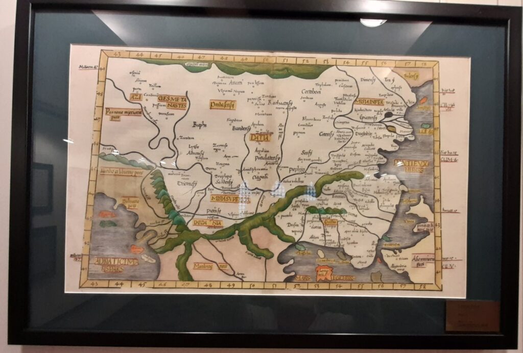
Its creator, Lorenz Fries (c. 1490–c. 1531), was an Alsatian physician, cartographer and astrologer whose interests extended across medicine, astronomy, geography and cosmography. A pioneer of Renaissance cartography, he collaborated with prominent mapmakers, including Martin Waldseemüller, adapting several of his maps.
In 1522, Fries prepared an edition of Ptolemy’s Geography that included 24 modern maps, three of which he revised himself. These maps were subsequently reused in later editions, including those published in Strasbourg in 1525 and Lyon in 1535 and 1541. The map of Dacia discussed here belongs to this tradition of bringing the ancient world’s geographical knowledge into the Renaissance. It appears as Map IX in the European series of the edition published in Lyon in 1535 by Christoph, Fries’s son.
Renaissance cartographers faced a difficult task. They sought to translate the geographical descriptions preserved by Claudius Ptolemy, the second-century Greek scholar, into maps that readers could understand. They combined classical accounts with observations and geographical information available in their own time. The results were remarkable achievements, even when distances, place names and locations did not correspond precisely to modern knowledge.
Fries also produced Carta Marina navigatoria (1516), a twelve-sheet woodcut map based on Waldseemüller’s work and regarded as the first wall map with German text. Many of Fries’s surviving cartographic works are now unique or exceptionally rare, making them valuable witnesses to the history of mapmaking.
For me, this map of Dacia carries a particular fascination. It is not a modern reconstruction of the ancient kingdom, nor can every detail be taken as geographically accurate. Instead, it reveals how Renaissance scholars interpreted the ancient sources available to them, preserving fragments of classical knowledge while adding the understanding—and sometimes the errors—of their own age.
And when a story leads me towards the Dacians and their lost treasure, such a map becomes more than an illustration. It is another piece of the puzzle: a reminder that the past reaches us through the hands of those who recorded it, each generation attempting to give shape to a world it could never fully see.
Maps and My Historical Fiction
As a historical-fiction writer, my fascination with this meticulous process is closely linked to my interest in the Ottoman Empire and the Mediterranean Sea.
Maps from these eras provide far more than historical information. They open a window into the strategic, cultural and economic landscapes that shaped Romania and the wider world.
Ottoman cartographic artistry, combining scientific precision with decorative flair, tells stories of conquests, trade routes and the intricate dance of diplomacy. Each map becomes a chapter in history, carrying echoes of explorers, merchants and empires that once flourished throughout the Mediterranean.
Studying these maps feeds my imagination and enriches my writing. They provide a tangible link to the past, something I can look at rather than merely read about, and that connection continually motivates my creative work.
Perhaps that is why maps fascinate me so much. They don’t simply tell us where people went. They can tell us what people believed was worth finding.
A Museum of Human Curiosity
The National Museum of Maps and Old Books contains maps of continents and oceans, war maps, treasure maps, moon maps, geographical maps, European maps and maps of distant lands. But behind all of them is the same human impulse: where are we? What lies beyond the horizon? Who lives there? And how do we get there?
Maps provide access to the world, inviting us to explore and conquer new territories. More importantly, they remind us to stay on track with our own souls and never lose sight of our destination. For me, every floor of the Map Museum provides another perspective on the rich history and art of cartography and every old map seems to whisper that the world was once both larger and smaller than we imagine.
We’ll return to it!
I did not know that during “the medieval period, many European maps placed east at the top”. That is interesting. I should say that the maps from 1500’s (16th century) of Scandinavia that I’ve seen had north at the top of the map. However, I checked and apparently that was a tradition that did not start until 1500’s. So, I learned something new.
Glad you did, Thomas. I was excited and surprised to learn about it too, although from a Christian POV it makes sense. At least now I know that if I can’t orient myself on an old map, this is why…
Fascinating information, Patricia, especially the orientation of maps. I remember being similarly confused when we studied a Medieval drama, ‘The Adam and Eve play’, in which Adam at one point referred to ‘Christ who me bought’. Wait a minute, there wasn’t any Christ yet, was there? The lecturer explained that time was understood differently back then, in a circular sort-of fashion. I can’t remember how it worked exactly – if I ever really knew – but putting time together with space (as in the maps) shows an incredibly different world view than that which we have now. Incredible. Thanks for sharing. 🙂
Mind bending, Laura, but I see your point there and I agree. I find it interesting how the view on life was once so different from ours, and perhaps hard to comprehend now because our brains are wired differently.
It’s a whole new world, Patricia.
Very interesting post, Patricia:) I love the old maps and never considered their importance.
So glad you enjoyed it, Denise. Old maps certainly have a story to tell 😉 sometimes even whimsical.
I believe you left a review of my microfiction story, “The Punishment,”on Amazon. Thank you so much! You really understood the story. I ordered two of your books and look forward to reading them.
Hugs, Dawn, yes I did. Your gothic horror microfiction The Punishment.It scared me well!
Thank you so much for your amazing support, Dawn 🙂
The Map Museum sounds like a fascinating place. I’ve always wondered how people managed to draw even a fairly small area without recourse to modern equipment. I didn’t know about east being the direction that was later replaced with north. I loved ‘Here be lions’!
It is a wonderful place, Trish. I’ve only visited once, but I think about it a lot 🙂 Yes, “here be lions” is such a novel idea. It’ll work even today (I, for one, wouldn’t step further). But I do wonder how many such unknown territories are left-if at all. Thank you so much for joining me 🙂